Geology of the Okanogan Highlands 2012
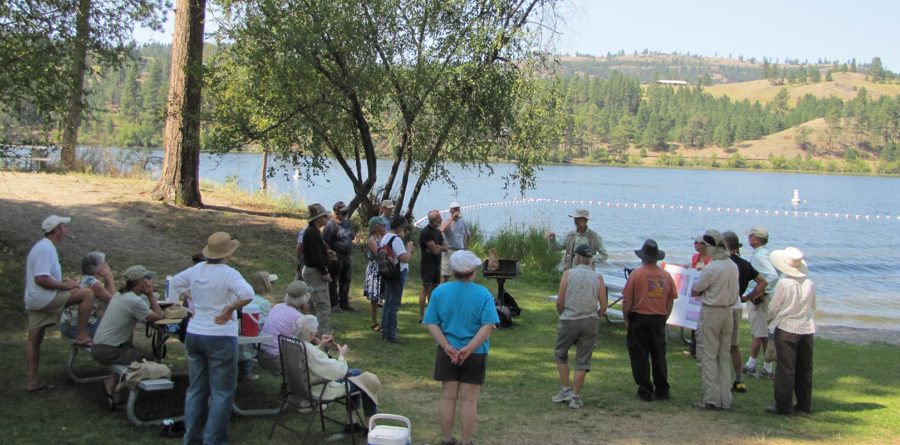
OHA’s 2012 outdoor Highland Wonders season closed with an all day tour, “Geology of the Okanogan Highlands,” led by Steve Box (USGS), Ralph Dawes (WVC), and Cheryl Dawes (B.S. Geological Sciences). Transported by a school bus, community members stopped in several locations along a loop that spanned the Republic and Toroda Grabens as well as the Okanogan Metamorphic Core Complex. From pictographs to garnets, and from volcanic/granitic faults to the highly unusual Corkscrew Mountain, the group considered a diverse array of features that shape the landscape as we know it.
Printable version of the 2012 Geology Tour handout
The geologists leading the event shared insight based on their experience and training. Participants learned about rocks and minerals (how to read them to understand the history and present-day geologic activity of the land), and structural geology (the history of faulting and other deformation preserved in the rocks). “I love learning, teaching, and sharing geological experiences because the planet we live on is, in its own way, a living, breathing entity, with its own distinctive behavior, its own anatomy and physiology,” says Ralph Dawes.
The geology tour explored the effects of a major change in tectonic plate motions that happened within the Pacific Ocean basin about 50 million years ago. “This change led to significant thinning of the continental crust across the Pacific Northwest, and most of the geologic features along the Hwy 20 corridor across the Okanogan Highlands reflect this event,” Stephen Box says. The group also discussed the faults that resulted, as well as the explosive volcanoes that erupted, the metals that were deposited when groundwaters became hot, and the granite that formed from cooled molten rock.
Participants considered how the rocks of the Okanogan Highlands are a combination of ancient North America, exotic terranes brought in by moving plates, and younger volcanic and sedimentary rocks that feature fossils and gold deposits. The tour also discussed the effects of the glaciation of the Highlands, which sculpted the peaks and left boulders from Canada strewn erratically on the landscape.
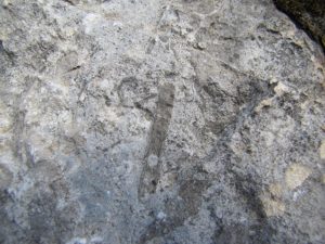
Stop 1: Mylonite
From the corner of highways 97 and 20 in Tonasket, drive toward Republic.
We are in the Okanogan Metamorphic Core Complex. The layers in this mylonite (Greek for “milled rock”) result from shearing, grinding and recrystallization of an original granite subjected to high temperature and stress within a deep-seated fault zone in the crust. This mylonite is part of the now inactive, 50 million year old Okanogan fault zone, along which igneous and metamorphic rock from deep in the crust rose to form a dome as overlying rocks slid to the west. Layered rocks like these crop out along the east side of the valley on the drive from Omak to Tonasket, forming what people in the area call “the flat-irons.”
Stop 2: Volcanic rock in contact with granite
Here the roadcut exposes 50 million year old flow-banded volcanic lavas on the eastern half, and older granitic rock with aligned dark minerals on the western half. Flow layers in the volcanic rock and alignment of dark minerals in the granite are sharply truncated at the contact (surface along which the different rock types touch), which indicates that the contact is a fault. This fault is a narrow fracture surface along which the rocks on either side have moved in opposite directions.
Stop 3: Republic City Park
Rocks passed around here were collected from the Tom Thumb Mine about 5 miles north of here. These white rocks are made mostly of quartz. They are typical of gold-bearing veins in the Republic area that were precipitated from hot water circulating through cracks within the crust during volcanism and faulting in the area, about 50 million years ago.
Stop 4: Greenstone
These rocks represent underwater lava eruptions and accumulations of fine-grained sediment that occurred on an oceanic crustal plate that lay to the west of the North American continent. Between 180 and 100 million years ago, motion between the earth’s crustal plates pushed these oceanic rocks up over the edge of the North American continent at a convergent plate boundary. These “foreign” rocks that were added to the older North American continent are part of an accreted terrane known as Quesnellia, named after rocks exposed near the town of Quesnel in British Columbia. As the rocks were shoved onto North America, they became slightly metamorphosed into a greenstone and were crisscrossed by faults and fractures.
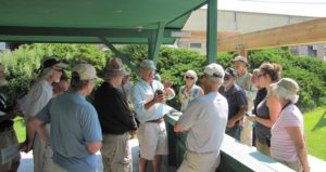
Stop 5: Bryozoan Fossils
The group did not stop here due to access issues, but information was provided by the presenters:
At the reclaimed portal of the Lamefoot gold mine (mined from 1994-2000), the rock is marble. Marble starts out as limestone, becomes buried deeper in the crust, and is heated to metamorphic temperatures, which causes it to recrystallize. The metamorphism of this marble occurred at a low enough temperature that, if you look very carefully and very closely at the rock, you may be able to see small fossils in it.
The fossils are the hard parts of marine organisms such as crinoids (stemmed echinoderms made of hexagon-shaped segments) and bryozoans (fine mesh structures, like tiny nets, that contained numerous tiny colonial organisms). The habitat of these creatures was a shallow ocean floor in a sunny climate.
The rock is part of Quesnellia and is of Permian age, between 250 and 300 million years old. The gold ore associated with these rocks, which we don’t see much evidence of here at the reclaimed surface, may have originated from a combination of volcanic and biochemical processes on the ocean floor. The location and concentration of the gold atoms in the rocks may have been modified by the warm water that circulated in cracks in the rock during the Eocene epoch, about 50 million years ago, when the Republic graben was forming. At this time, rocks in the area were being faulted and shifted, and volcanoes were erupting nearby.
Stop 6: Curlew Lake State Park
Curlew Lake is in a valley formed by erosion at the base of a continental glacier, known as the Cordilleran Ice Sheet. The ice sheet originated in the mountains of western Canada and covered a large part of northwestern North America, reaching a maximum extent about 20,000 years ago, and then melting away by approximately 10,000 years ago. Glaciers consist of moving, flowing ice, which over this valley may have been the better part of a mile thick. The hills on the far side of the lake are long ridges that are streamlined in a north-south direction, sculpted by the south-flowing glacier that covered this entire landscape. The valley of Curlew Lake was a pre-existing stream valley, which had its drainage altered and divided as a result of the glaciation. Sanpoil Lake and Curlew Lake are in the same valley, with less than 3 miles between them. Sanpoil Lake drains south into the Columbia River. On the other hand, Curlew Creek, the outlet stream of Curlew Lake, drains north into the Kettle River. This is an example of what is called a deranged stream drainage system, a common effect of recent glaciation.
Stop 7: Migmatite
In the Okanogan Highlands, the down-faulted grabens are mostly filled by volcanic and sedimentary rocks from the upper crust. Up-faulted blocks bordering the grabens are rocks of the metamorphic core complexes, which consist of metamorphic and granitic rock from deep in the crust that domed upward and became revealed at the earth’s surface by erosion.
Stop 8: Granite and Breccia
The parking pull-out for Stop 8 is on the Bodie Mountain fault, the main fault along the east side of the Toroda graben.
Stop 9: Corkscrew Mountain
Corkscrew Mountain is interpreted as originating in a volcanic “pipe,” a conduit, through which magma moved upward to erupt as lava on the earth’s surface. Somehow, the magma solidified and cooled within the volcanic conduit into the pattern that has been revealed and etched out by subsequent erosion.
Suggested resources:
- Northwest Exposure: A Geologic Story of the Northwest by David Alt and Donald Hyndman
- Roadside Geology of Washington, also by David Alt and Donald Hyndman, Mountain Press Publishing (Missoula, Montana), ISBN 078-0-87842-160-2
- The Roadside Geology series of books also includes other states that may be of interest
education, events, field trip, geology, highland wonders, rocks